
Researchers have found a way to turn ordinary 5G signals into a passive radar network for the drone economy — no extra hardware needed
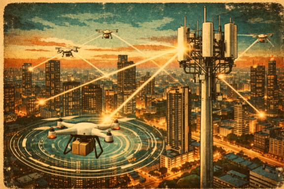
The skies above cities are getting crowded. Delivery drones, air taxis, inspection UAVs — the low-altitude economy is arriving faster than the infrastructure to manage it. Now, a team of engineers from Nanjing University, Nanyang Technological University, and the University of Waterloo think they have a surprisingly simple answer to a complex problem: use the wireless signals already bouncing between drones and cell towers to track those drones in real time.
No dedicated radar. No extra spectrum. Just the signal that was already in the air.
Their paper, published in February 2026 in IEEE Transactions on Network Science and Engineering, proposes a system where multiple base stations cooperate to pinpoint a drone’s location and velocity by measuring something every cell tower already has to measure anyway.
The Free Measurement Hidden in Every Signal
When a drone flies through the city, it’s moving fast relative to the cell towers it communicates with. That motion stretches and compresses the radio waves it transmits, a well-known effect called the Doppler shift. It’s the same physics that makes an ambulance siren sound higher-pitched as it approaches and lower as it drives away, just applied to radio waves instead of sound.
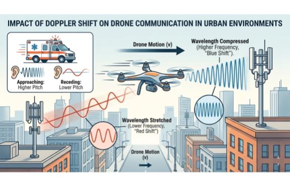
In any modern cellular system using OFDM, the signal format underlying 4G and 5G, every base station already has to measure and correct for Doppler shift just to decode the incoming signal properly. If it doesn’t, the data gets garbled. The correction happens automatically, as part of standard signal processing, using a portion of the signal called the cyclic prefix.
The researchers’ insight is that this correction measurement is effectively a free Doppler reading. And a Doppler reading, it turns out, contains information about where the drone is and how fast it’s moving.
Each base station sees the drone from a different angle, so each one measures a slightly different Doppler shift. Collect enough of those measurements from enough towers, and you can solve a system of equations that tells you exactly where in three-dimensional space the drone must be for all those readings to make sense simultaneously.
“The Doppler shift observed at each base station can be mathematically modelled as a set of equations, where the speed and position of the aerial vehicle are the unknown variables,” the authors wrote in a statement. “By solving this system of equations, the position of the aerial vehicle can be accurately determined.”
No radar ping. No dedicated sensing signal. The drone is located using the data transmission it was already sending.
A New Kind of Network Architecture
The system relies on a proposed next-generation network design called FD-RAN, or Fully Decoupled Radio Access Network, which is being developed as a core concept for 6G. In a traditional cellular network, each tower handles both sending and receiving signals together. FD-RAN splits those roles apart: separate, simpler base stations handle uplink (receiving) and downlink (transmitting) independently.
For drone tracking, this turns out to be a major advantage. It allows a dense grid of inexpensive uplink-only receivers to be deployed across a city, all feeding their Doppler measurements to a central edge cloud that does the localisation math in real time. The more towers listening, the more accurate the position fix.
The team also developed an algorithm they call LADF, for Learning-based Adaptive Double Filter, to turn individual position snapshots into a smooth, continuous flight path. Drone trajectories are physically predictable: a quadcopter can’t teleport. By training a deep learning model on the temporal patterns of how Doppler shifts evolve over time, and then layering a classical Kalman filter on top to enforce the physics of motion, the system can maintain an accurate track even when the raw measurements get noisy.
Why This Matters for Urban Air Traffic
Right now, managing drone traffic in cities is an unsolved problem. GPS works well in open fields but degrades near buildings. Dedicated radar systems are expensive and raise spectrum allocation questions. Requiring every drone to constantly broadcast its own GPS coordinates puts the privacy and bandwidth burden on the aircraft and creates a single point of failure if that broadcast is jammed or spoofed.
A passive system built on existing cell infrastructure changes the equation. The network does the sensing, not the drone. An unauthorised drone that isn’t cooperating can still be tracked, because it can’t avoid creating Doppler shifts when it moves.
The researchers ran extensive simulations to test the system’s performance under realistic noise conditions and confirmed it could maintain accurate trajectory tracking across a range of vehicle speeds and network configurations.
What Comes Next
The results are promising, but there are important caveats. The work is simulation-based, with no real-world flight tests conducted yet. The FD-RAN architecture it depends on is still a 6G concept, not something you’ll find in a commercial network today. The paper also doesn’t fully address what happens when dozens of drones are flying simultaneously in the same airspace, which is precisely the scenario cities will eventually face.
But the core idea is already generating attention from the research community. With regulators in Canada, the United States, and Europe actively working on frameworks for urban air mobility, the pressure to find scalable drone-tracking solutions is intensifying.
The answer, it seems, may already be mounted on rooftops across every major city. It just hasn’t been told to look up yet.
Sources
Quotes in this article are drawn from a paper published in IEEE Transactions on Network Science and Engineering by Xue et al., accepted 6 February 2026, DOI: 10.1109/TNSE.2026.3663391. The research was supported by the National Natural Science Foundation of China.
More Like This
- New System Uses Smart Surfaces and Room Reflections to Boost Future 6G Signals
- Engineers crack 6G’s biggest indoor problem with a device that looks like a clothespin

Ray Jackson holds a BSc in Electrical Engineering from the University of Manitoba and a PhD in Physics from Carleton University. His reporting interests include Current and Future Technologies, Engineering and Artificial Intelligence.